A Small Boat Cruising Primer for the Brave, Hardy,
or Foolish
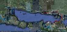
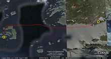
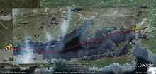
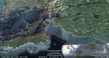
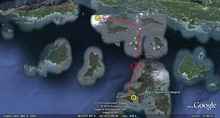
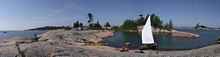
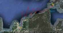
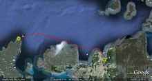
To Recap: The image above shows the northern end of Lake Huron,
with the western end of the North Channel at the center, just
north of Drummond, Coburn, and Manitoulin Islands. The red line
is a rough approximation of the course we followed during the
second week of our North Channel trip. The first week’s
progress is shown in white.
Week 2—Turnbull Islands to Cape Roberts
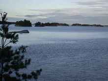
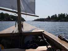
DAY 8: The run to Beardrop Harbour. (8 miles)
My VHF radio tells me to expect west winds at 15-20 knots. Good
thing I’m headed east. It’s about six miles from the
eastern edge of the Turnbulls to the mouth of the Whalesback Channel—far
enough for me to learn a few more things. Namely:
1) 15-20 knots is pretty windy in a boat like Jagular.
2) Yes, I knew that already. But still.
3) That brief lull in the wind? The one that seems like it’ll
last long enough to make it worthwhile to take out the reef you
tied in? It won’t.
4) Not all Labrador Retrievers are good swimmers.
5) But that doesn’t stop them from trying real hard.
6) Blueberries. Mmmmm.
7) The Labrador equivalent of “Blueberries. Mmmmm.”
is “Fish heads??!! FISH HEADS??!!!”
8) If you’re betting on a tug-of-war match between a large
dog and a small boy, don’t put your money on the boy.
9) The odds of needing to rescue a dog from a cliffside more
than once in your life? Better than you might think.
10) The odds of a typical North Channel cruiser actually resorting
to the use of oars to propel a dinghy? About the same as the odds
for a Rebel soldier to survive a night outdoors on the surface
of planet Hoth, as calculated by R2-D2 in opening scenes of The
Empire Strikes Back.
11) Or maybe slightly worse—Han and Luke DID survive,
after all.
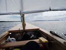
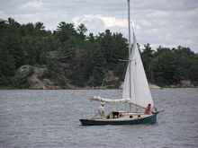
Setting out from my camp in the Turnbulls on
Day 8. In the 2009 Texas 200, duct tape was an essential component
of my jury rigging efforts after we lost our mast. It proved
just as useful for stopping the leak in my drysuit.
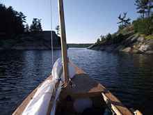
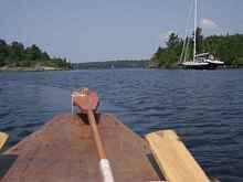
Sailing eastward from the Turnbulls to the Whalesback
Channel. Sharp-eyed readers may spot a package of Strawberry
Newtons on the thwart—a meek and poor-spirited substitute
for Raspberry Newtons, but all I could find for this trip.
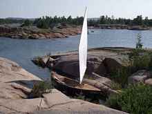
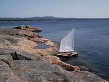
Jagular tucked into the lee of the tiny unnamed
island that shelters Beardrop Harbour from westerly winds.
Just moments after I finished setting up the tent, the island
was invaded by a small boy and two large dogs. We had a good
time.
The skipper and builder of this handsome Reuel
Parker sharpie (modified to include a 3’ ballast keel)
is a professional sailor and tall ship captain. His one-person
crew is a kindhearted lady who fed me well. They arrived in
Beardrop Harbour not long after I did—the only other
wooden boat I saw (Unless you count his tender, a Joel White-designed
plywood lapstrake Shellback Dinghy).
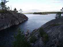
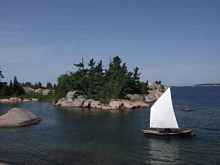
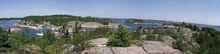
Beardrop Harbour from the high cliffs to the
east—obviously a popular anchorage among North Channel
cruisers. The rocky island in the center of the bay is our
campsite for the night.
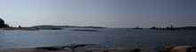
Looking east down the Whalesback Channel from
the cliffs above Beardrop Harbour. My favorite part of the
trip, worth two weeks all to itself.
The sneaky back exit from Beardrop Harbour.
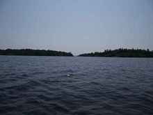
Evening in the Whalesback Channel, just outside
of Beardrop Harbour.
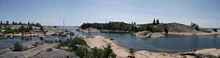
DAY 9: The Whalesback Channel to Spanish Marina. (14 miles)
Ok, so here’s what today taught us:
1) Happiness is a drysuit on a tough beat.
2) Canadian marinas. Mmmmm.
3) Arrive at that small-town grocery store in a car and it’s
a small-town grocery store. Big deal. Arrive on foot (a two-mile
trip each way) after sailing all the way from Michigan in a small
boat, and it’s both a Destination and an Oasis of Luxury.
4) When it’s 80 degrees (Fahrenheit—sorry, Canadian
readers!) outside, a Fudgesicle does not fall into the “non-perishable
goods” category.
5) Grape tomatoes. Mmmmm.
6) That noise outside your tent in the middle of the night? The
one that sounds like a smilodon tearing apart a Percheron stallion
just a few feet from your rainfly? Probably not a good idea to
step outside and check what that is.
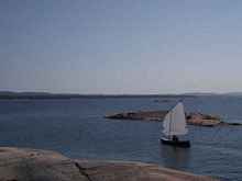
Jagular heading out Beardrop Harbour’s
back door.
One of them islands somewhere on the chart.
Mulock? Parsons? Greenway? Ah, who cares? We’re heading
east. I know that much, anyway. (GPS, hell!)
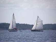
Put two sailboats together and it’s a
race. The tall ship captain chasing down his friend Bill,
who’s a retired junior high math teacher. I guess all
that “the shortest distance between two points is a
straight line” stuff actually works.
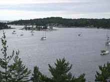
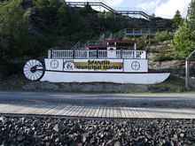
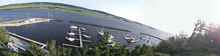
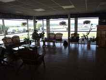
Canadian marinas: Clean. Hassle-free. Friendly.
Artful faux-riverboat décor. Got to love ’em.
The hill behind this one is actually tall enough
for you to see the curvature of the earth from the summit.
If you squint hard enough, you can just make Jagular tied
up at the visitor dock on the left-hand side of the picture.
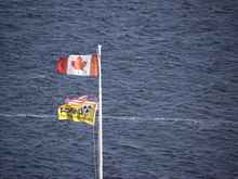
The marina flagpole. Guess which way we have
to travel next? Guess why we’re not going any further
today?
All of this was free. Free bathrooms. Free showers.
Free library. Free parking. I met a guy in a Potter 14 who
left his car and trailer here for a week of cruising, no hassles
at all. And a credit card-operated phone and coin-op laundry
open to everyone who comes by, no questions asked. Socialism
is a terrible thing, isn’t it?
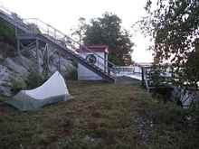
The free campsite I would’ve paid $32
for on Drummond Island. That’s $32 for one night, by
the way. And no faux riverboat.
DAY 10: Spanish Marina to Crooks Island (6.5 miles)
Spent a good part of yesterday hanging out with new friends:
Hugh (the tall ship captain) and his crew Julie, and their friend
Bill (the retired math teacher) and his crew Nan. They all left
last night, and I’m back on my own today. But I may see
them later—I was invited to stop in at Hugh’s house
(an off-the-grid hand-built home with no road access) on the south
side of Drummond Island on my way back. We’ll see. Today,
it’s on to the Benjamin Islands. If I make it that far.
Words of wisdom?
1) Big sailboats do an awful lot of motoring.
2) But we knew that already, didn’t we?
3) Remember that really windy day last week? When we almost capsized
while running dead downwind?
4) Today looks kind of like that, doesn’t it?
5) But it’s not nearly as scary once the sail isn’t
up anymore.
6) And there’s an island right over there.
7) With a little stretch of gravel beach.
8) And there’s no reason we need to get to the Benjamins
TODAY, is there?
Sometimes it helps to know where you’re
going. That narrow passage up ahead is known as Little Detroit—it’s
about the only way to get from the Whalesback Channel to the
Benjamin Islands by boat.
Jagular heads into Little Detroit. By the chart, we’re
pointing southeast. By Jagular’s compass, northeast.
That’s why the compass spent the rest of the trip
folded down against the mast partner, as you see it here.
There’s $5.99 wasted.
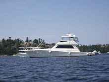
A big powerboat heads west through Little
Detroit. Hmm… I wonder what that tall mast and all
those lines and stays are for. Better radio reception, maybe?
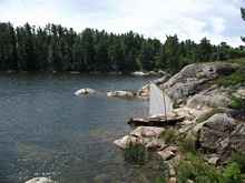
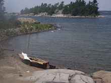
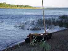
Jagular ashore on Crooks Island, a brief respite
from strong westerly winds.
Which turned into an overnight stay, an on-foot circumnavigation
of the island, and a session of cliff jumping and swimming.
Crooks Island is pretty cool. And it was pretty windy.
DAY 11: Crooks Island to Indian Pass via the fabled Benjamin
Islands (16 miles)
Today’s the day we’ll finally reach the Benjamin
Islands (or “the Benjies,” as they are never called).
I’ve been looking forward to the Benjamins with a mixture
of eagerness and dread ever since I started hearing about them.
Beautiful? No doubt. Crowded to the point of being loved to death?
We’ll see. My arrival in the Benjamins will also mark the
geographical halfway point of my trip. Given the usual wind patterns,
everything after this could be uphill all the way.
Here’s what I figured out today:
1) Yes, the Benjamin Islands deserve their reputation for beauty.
Crowds? Well, in a boat like Jagular you can always find a quiet
corner somewhere.
2) It’s the IDEA of other people that worries me. When
I actually MEET those other people, most of them turn out to be
ok.
3) Especially when they offer to cook me breakfast.
4) The number of beautiful scantily-clad women riding in powerboats
is strikingly higher than the number of beautiful scantily-clad
women riding in sailboats.
5) Which makes the presence of so many powerboats a little more
tolerable.
6) And you can make progress rowing to windward in some pretty
strong winds.
7) But you won’t like it.
8) That sneaky back way into Indian Pass? The one where the blades
of your oars were hitting bottom on every stroke, despite not
even being fully submerged? Yep, it’s pretty shallow there.
No keelboats allowed.
Coming into the Benjamins from the northwest
(or, from the south-southwest according to Jagular’s
compass—I checked).
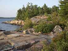
“Rocky” is an adjective that is occasionally
applied to the Benjamin Islands. (It can get crowded here;
we reserved this slip a couple months in advance.)
Rocky. Yep, that works.
These kayakers were cooking breakfast as I sailed
by. They waved me in so they could have a better look at Jagular.
Then they tried to feed me. (And here I’d been assuming
that the constant offers of food had something to do with
the relative sizes of my boat to my hosts’ boats.)
More rocks. And technically, we haven’t
even reached the Benjamins yet.
Landfall on North Benjamin Island. This picture
was taken from the best jumping-off rock of the whole trip—a
twelve-foot drop into clear, cool, deep water.
Ok, so they were right about the crowds—at
least, in the main anchorage between North Benjamin and South
Benjamin Island. This mongosso power cruiser cut across my
bow throwing a four-foot wake. I doubt anyone aboard even
noticed me.
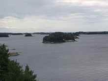
A quiet cove tucked in among the rocky islands
just off the southern tip of South Benjamin Island. And
yes, the folks on those bigger boats invited me to stay
for supper.
In fact, the left-most boat in this picture is Anne Westlund’s
RAGGEDY ANNIE; it was Anne’s
writing that inspired me to cruise the North Channel
in the first place. I had tried to meet her on Drummond Island
a couple weeks earlier, but she was already gone cruising. And
so we met here, by chance, instead. The North Channel is a small
world.
Looking north toward South Benjamin Island
from the rocky summit just off its southern tip.
Looking south toward Clapperton Island—my
next destination—from the same spot.
DAY 12: Hanging out at Indian Pass (0 miles)
Windy! Just as the forecast predicted, the wind is howling out
of the west today. Swam over to Clapperton Island and spent the
day walking down to the southern tip and back, then spent the
evening reading Mark Twain’s Life on the Mississippi in
camp, learning:
1) It’s a lot easier to swim east in strong westerly winds
than it is to swim WEST in strong westerly winds.
2) One book is not enough.
Since the forecast 25-knots-plus westerly winds
arrived right on schedule, this is how Jagular spent the day.
A perfect spot, actually, tucked into the lee of Vankoughnet
Island on a gently sloping gravel beach. Meanwhile, breaking
waves shut down both the northern and southern entrances to
Indian Pass all day long.
DAY 13: Indian Pass to Gore Bay (23 miles)
Today’s promised south winds turned out to be southwest
instead. Of course, we’re heading south. And west. I’m
actually not sure I can get back to Drummond Island in the allotted
time, given the prevailing westerlies—I’ve been considering
just keeping on east through the North Channel and even Georgian
Bay, hopping a bus to return to my car, and coming back later
for the boat. Today will decide it. If we can make progress in
these winds, we can make it back. Today’s lessons?
1) Those shoals marked on the chart? The ones marked “Boulder
Bank?” Yep, the water’s real shallow there.
2) And bouldery.
3) We CAN make progress to windward.
4) Slowly.
5) And partly by rowing.
6) With careful timing of tacks between wave crests when sailing.
7) Which won’t be real dry.
8) Hence the drysuit.
9) Whose duct tape repair is still holding up.
Still windy. Even the big boys were taking
a bit of a pounding today, but Jagular made it in to Gore
Bay without much of a fuss.
Gore Bay Marina; I didn’t see the need
to pay for a slip when this stretch of lawn would do just
as well. The trick is to ask permission (if you feel you
must) from the teenage labor force, not the owner. They
won’t care.
It doesn’t take much to seem truly
luxurious after a long day of rowing and beating to windward.
DAY 14: Gore Bay to Cape Roberts (19 miles)
A long day, one that started with such promise. Southeast winds
in the forecast, nothing but blue skies overhead. It sounded so
good that I left the B&B I stayed at (Martha’s Inn)
without waiting around for the second B. Although I did drink
a glass or two of fresh-squeezed orange juice. Southeast winds!
Just what we needed to make some progress back toward Drummond
Island and close the loop. And for about half the day, that’s
what we got. But by the time we reached Cape Roberts, we learned:
1) A boat like Jagular will keep moving with very little wind.
2) But it won’t move fast.
3) Unless you row.
4) A lot.
5) Which, actually, won’t be that fast either.
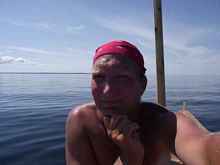
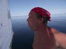
Self-portrait of a sailor in search of wind.
It was worth a try.
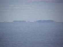
Some people will tell you there are no tides
on the Great Lakes. Not true. On a really big spring tide,
water levels can drop so far that the islands are left high
and dry, floating in air. We’re near the turn of the
tide now in this photo of the Benjamins.
Video: The breadstick test, a little-known variant on the traditional
chip log.